Meet Report: 6-20 April 2024.
Following a well-attended club meet in Tafraout in 2009, an excellent trek across the Jebel Sarhro in 2016 and a meet in 2020 cut short in its prime by Covid-19 after the first week in Tafraout, we returned to the Anti-Atlas area of Morocco having planned a fortnight’s trip in two halves. Eleven members flew into Agadir and hired cars to travel to the market town of Tafraout for a hotel-based week of walking, scrambling and trad climbing. Two members then flew home while the others went to Taroudannt to be joined by three more for a six-day camping trek, culminating in an ascent of Jebel Siroua (3305m), the highest peak in the Anti-Atlas.
TAFRAOUT WEEK
Saturday 6th
Arriving in Agadir airport on late evening flights, we transferred to the Odyssee Park Hotel in Agadir rather than attempting the long drive to Tafraout over the narrow, sinuous and potholed mountain roads in the dark.
Sunday 7th
After breakfast and hire car collection, we drove to Tafraout via the Kerdous Pass where the café was unfortunately closed due to Ramadan. We were again warmly welcomed into the Hotel Les Amandiers by Mohamed and his friendly staff, and enjoyed a cold beer after our long drive before walking down into town.
Monday 8th
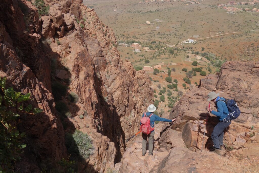
Inspired by enthusiastic descriptions in both guidebooks, we all decided to make the long drive over to Tanalt to climb the spectacular pilgrims’ path up Adad Medni (1405m). This mountain is at the western extremity of the Anti-Atlas and was unusually wreathed in mist! The convoy got separated in the fog on the access track and one car turned back. The rest were met by a Berber at the car park who explained the potential perils and difficulties of an unguided ascent in the misty conditions using Google Translate on his mobile phone! However, after thanking him, we all enjoyed the ascent up the clear but exposed Berber path to the saint’s tomb on the summit and carefully avoided the spiny Euphorbia echinus plants with their poisonous sap. The mist obstinately remained and so no long-distance views were had, but the route was so pleasant that most vowed to visit again in better weather. We returned via the abandoned village of Temghist and its rare Dragon tree.


Abandoned by the convoy leaders, Michael, Helen, Richard and Peter drove back down, out of the cloud, to the Tirki river valley, parking by the bridge. Initially on flat slabs then increasingly up over higher strata, a lunchspot by a pool was chosen with swallows, martins and a Moutier’s redstart for entertainment. Upstream there was more boulder clambering and steeper scrambling by cascades. After several bends in the river a crossing to the true right bank was required to rise to a col. Arriving there revealed they had crossed too soon. Undaunted, they contrived a circular route by crossing back over and recrossing further downstream to angle up onto a ridge leading back towards the parking spot. A loose bunch of bee-eaters flew around. The final descent was steeply down an irrigation channel through steep, treed terraces.
Tuesday 9th
Mick, Tim, Conrad and Richard set off for a superb scrambling ascent of Jebel el Kest by an intricate and varied route from Afantinzar on its northern side. Route finding via a steep and vegetated gully and a cairned trod up through prickly scrub to the foot of JEK’s West Ridge was relatively straightforward, but identifying the correct gully to ascend took a couple of attempts. Careful grade 2 scrambling up this led to the cairned ridge that took us to JEK’s south summit (2375m) and its hazy view. Richard was unfortunately overtired at this point and a wise decision was made to slowly return by the ascent route to avoid being benighted, leaving JEK’s north top and its interesting descent for another day. Mick’s Garmin inReach device was used to email the rest of the group via the Iridium satellite network to inform them that we were all okay, but would be very late for dinner. We arrived at the car having narrowly avoided using our headtorches.


Michael, Helen, Peter, Alan, Steve, and Ian walked from the hotel to the impressive Elephant’s Trunk granite tor. While Alan conserved energy in the shade of a tree the others scrambled up the head. Back down they headed for the right-hand col over into the Ameln Valley in blazing heat. Peter, better suited to arctic conditions, returned to the shade of the hotel. Five took the rough track down to Tirgult by the road where, in the absence of a shop, a public water tap allowed Ian to refill his water bottle and provided shade for a snack. After, Ighaln, the next village to the west, their GPX track indicated a rising traverse crossing steepish slabs divided by gullies. Michael continued this grade 3 scrambling to within sight of one of the two tops above Ighaln from where he spotted the more sensible four on the valley track below. After communicating to them that he was okay he realised blood-sugar and water were running out and roped down the steeper sections, to reach the road and hitch back to Tafraout (80p). Meanwhile, the four below had rejected the idea of hitching back and continued up towards a high sparse pasture. Food, water, and themselves almost exhausted they reached a goatherders’ hut and made conversation. Helen asked if they could spare any water and a 5 litre bottle was gratefully accepted. They continued out of the back of the pasture, over a col and past the Berbers tents to Tafraout, arriving as the last of the light was fading. After a restorative bottle of Fanta they climbed up to the hotel where a concerned Michael had been scanning the approaches with binoculars.


Bev chilled out by the pool at the hotel.
Wednesday 10th
Mick and Tim decided to return to the north side of JEK to do the very pleasant circuit from Tassila which passed the quartzite cliffs known by climbers as the Golden Cirque. This was combined with an ascent of Afantinzar Peak (1992m). After lunch at a shady cave, this summit was reached by an easy scramble up a gully and rocky ramp. The circuit was completed by descending the valley below Adrar Iffran where Tim had climbed on a previous visit.


Michael, Helen and Peter ascended Jebel Amagdor from Tizgut after locating the correct tree marking the foot of the guidebook’s (not so) obvious gully. Turning right they scrambled along a ridge and descended through disused almond terraces. Michael, reaching a drop, put up a pair of Dorcas Gazelles. Searingly hot day.
In anticipation of a very hot day, Richard decided on a quiet day. After a fruitless search for the still closed market (due to Ramadan), a retreat was made to closely inspect the hotel pool and its service options. In the afternoon with Steve, Bev, Conrad and Ian an appreciation of art visit was made to the Painted Rocks. They initially had a look at the first group and then walked down to the larger cluster of blue, pink and yellow boulders in the valley bottom. Conrad climbed up to almost the top of the highest boulder but the adhesion offered by the paint combined with a lack of friction on his shoes meant he didn’t bother chancing climbing to the absolute top. On the way down, he met Steve and they did a circuit of the base of the rock cluster. When they finally met up with Richard et al, another group had assembled at the base of the rocks on adventure motorcycles and two classic Mercedes-Benz W123s. Richard ascertained they had done around 500,000kms apiece! Richard took the scenic route back through the desert and via the bumpy ‘washboard’ road through Aguerd Oudad back into Tafraout.
Alan meanwhile relaxed at the hotel and organised some other trekking parties.
Thursday 11th
Mick led a large party up to the prominent summit of Tasselt (1961m) from Tizi Ou Manouze for an easier day. Wide-ranging views across the Western Sahara and the Anti-Atlas were enjoyed with Adrar Ameurksou dominating the scene across the valley. Lunch was taken at the summit and a number of colourful butterfly species encircled us including several swallowtails. Richard took Helen and Peter on a tour of the Painted Rocks on the way back.


Michael and Tim went round to Sidi M’Zal, walked up to Red Slab after searching a kilometre or so of crag, climbed Absent Friend D *** 40m in short order and wished it had been much longer.


Friday 12th
Mick, Tim and Ian drove to Ida Ougnidif near Kasbah Tizourgane to walk the Berber trail leading up to the mountain village of Tagdicht. The return was made by a superbly engineered Berber path that made a spectacular descent into the lower Tagdicht Gorge by an unlikely route down a steep rocky rib and gully – the entertaining highlight of the circuit.


Peter, Richard and Steve from the Idekel turn-off toured the ‘Cobalt mine’ (probably a failed prospective level) then scrambled up onto the Idekel ridge and along it over a couple of towers. Steve and Michael walked on to nearby Adrar Idekel (1778m), and back before descending northeast back to their car.


Helen, Alan, Conrad and Bev had a quiet, restful day relaxing on the terrace.
Saturday 13th
We decided to fit in a short route on the way back to the airport to drop off the hire cars. Since we would be going via Ait Baha, we did a circular walk from Kasbah Tizourgane taking in the easy scramble to the ruins of the Tamgelochte Fortress and its view across to the Tagdicht Gorge.
Conrad and Bev waited for their return flight to the UK while the rest took a minibus to our hotel in the walled city of Taroudannt, where we were joined by Richard, Fliss and Andrew, who had been out exploring the town after their early morning flight. We enjoyed an excellent dinner and met Abdullah Agafay (known as Abdu), who would be our guide for the Jebel Siroua trek.
Jebel Siroua Trek
Sunday 14th
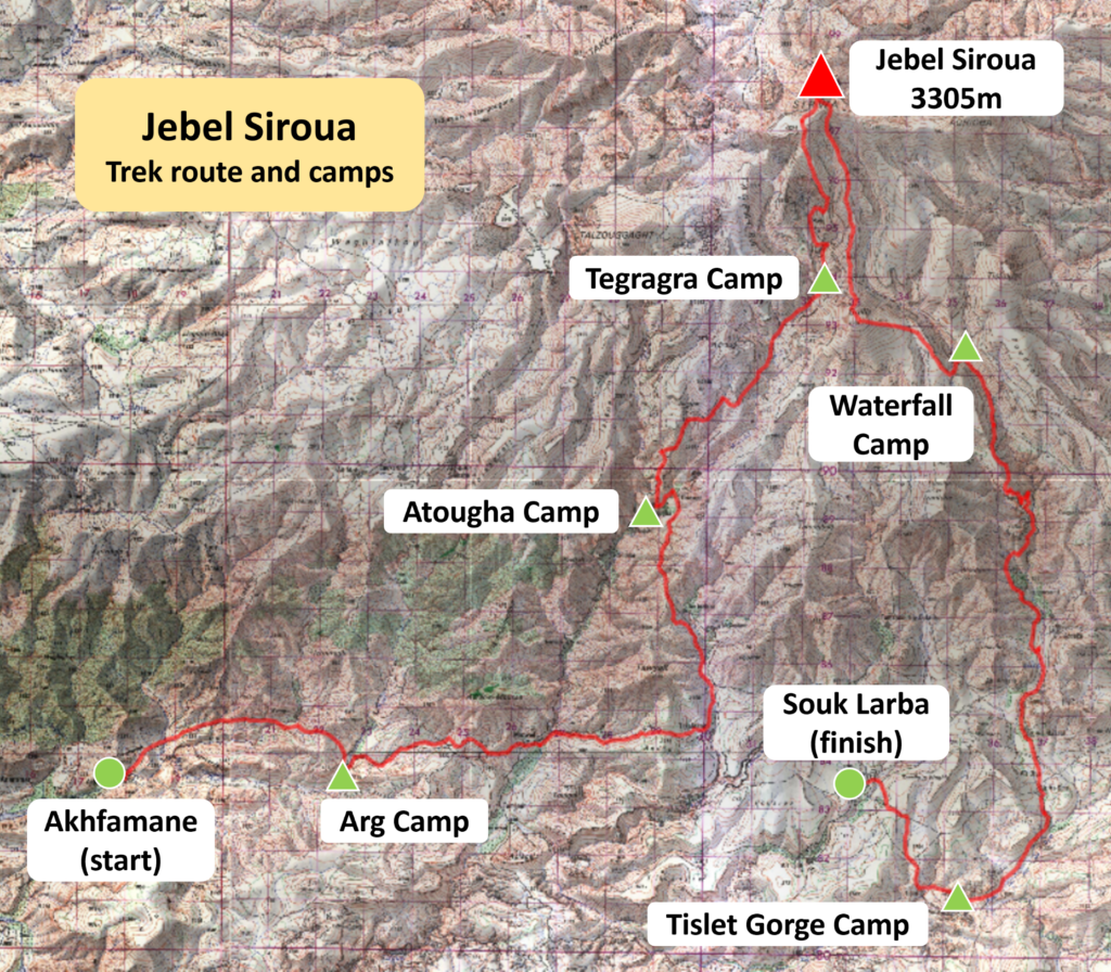
After a hearty buffet breakfast, we put our unneeded baggage into hotel storage and set off once more in our minibus, first eastwards, briefly breaking our journey at Taliouine for refreshments, then turning to the north to follow the banks of the Oued Zagmouzene, back into the mountains as far as the village of Akhfamane.
At this point we were united with our cook and no fewer than eight muleteers who would accompany us throughout our trek. Here at Akhfamane we took the first of a series of splendid daily lunches under the shade of a copse of trees. We learned that our cook, Hussein, had been employed at the prestigious Kasbah du Toubkal, Imlil, until his recent retirement. We were very lucky to have him; not only these lunches but wonderful evening meals, too, would become a recurring hallmark of this trek.
In the afternoon, we began the walk itself, setting off further northwards across a largely barren yet colourful landscape, a sign of the recent years of drought suffered in the south of Morocco. After a fairly short afternoon’s walk, we passed through the village of Arg and, from a small promontory, found ourselves looking down onto a cluster of green tents, already assembled for us by our team of muleteers, our first camp site, on the far side of the village.


Monday 15th
We had heard that the road leading through the lower part of the Zagmouzene Valley, since our first plans to trek this route in 2020, had been extended as far as Atougha. To avoid this section, we adapted the originally planned route and, instead of continuing directly up valley, crossed the main valley at Mazwad and then headed into a side valley, running broadly in parallel, to the east. Although a slightly longer route, it made good sense to switch rather than to walk along the new road. That said, the mules did continue along the originally planned route, so as to cover the ground more quickly, and they made a splendid sight, picked out by the bright early morning sun, making their way on the far side of the valley, soon some way below us.
We next walked through a couple of small villages, where the local inhabitants cannot have been used to seeing passing trekking parties, eventually crossing back into the main valley. We found ourselves looking down from some height onto the picturesque village of Atougha, its traditional houses clustered around the fine white minaret of its mosque, its verdant terraces cascading below, all the way down the hill side to the valley floor.
We camped for the night under bright stars and a perfectly clear sky on a threshing floor on the very edge of the village.


Tuesday 16th
Today we began with a steep ascent through the unpaved lanes of Atougha, rising past the ruins of its historic agadir (granary) and then two isolated abandoned marabouts (burial places or shrines of saints) overlooking the village. Although there were signs of a few modern incursions such as random satellite dishes, there was still no more than a handful of these and, for the most part, the village had stayed very true to its traditions.
Still we rose, the land intermittently levelling out before rising once again. Along the way, we passed occasional Imazighen (Berbers) who somehow continued to make their living in this isolated, elevated place. First, a sole man riding his donkey to his fields, then a couple of young women chatting above us before their summer home, then a group of men releasing their sheep and goats from the walled pen of their azib (animal pen) and leading them out to their feeding grounds.
We paused for lunch at Azib Ouamran, a small summer pasture, where several of our group took the opportunity to bathe their feet in the gurgling stream while Peter demonstrated how we might invert hatfuls of delightfully cool stream water directly over our heads.
The short afternoon walk led us onwards to Tegragra, the highest of the summer pastures above Atougha. As we approached, we saw bright orange tents on the western slopes which we discovered belonged to a French trekking group. Only Michael, clutching a wad of YRC business cards, was brave enough to pay them a visit, while the rest of us opted to head straight to our camp, located at a safe distance on the centre of the pastures.


Wednesday 17th
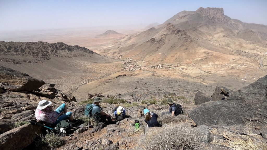
The ascent to the summit of Jebel Siroua (3305m) from Tegragra involved a number of short, steep climbs and traverses across mostly flat, boulder-strewn ground until our arrival at the base of the distinctive volcanic plug. On a clear day, it can be seen all the way from Jebel Toubkal in the High Atlas, far away to the north. All that was still required to reach the very summit was a short 10-minute scramble, involving some use of hands, across bare rock. Once atop, we were rewarded with ample opportunities for selfies and groupies.
Shortly after beginning our descent, the group divided into two. Ian, Steve, Andrew, Richard T and Mick opted first for the summit of Jebel Guiliz (2905m). From the top, they made a beeline for a Berber shepherd sat on a rock, who turned out to be the father of one of our muleteers! He offered them a cup of tea which was graciously accepted and they watched him skilfully make a small but intense fire and boil the water in a a blackened teapot. Some green gunpowder tea and a piece of lump sugar was then added. Excellent!
The rest of our group, conscious of the day slipping by faster than they might have wanted, chose to head straight to Waterfall Camp, following a delightful stream, occasionally switching banks, flowing down through a beautiful, narrow valley, at times flanked by impressive crags.


Thursday 18th
The descent continued onwards, still following the stream. As the valley widened, occasional terraced fields cut into its sides forewarned us that we were approaching Tizgui, the highest village on this side of Jebel Siroua.
The village was, in fact, the home of Ahmad bin Rhu, one of our muleteers and assistant guide, who kindly invited us into the salon of his house for mint tea and light snacks. Even better than the refreshments, however, was the far-reaching view, which we enjoyed from our seated position, and the soothing cool air entering the room through its open iron-grilled windows. Ahmad next produced small bottles of locally-produced saffron (the Taliouine region is the major saffron-producing region in the world) which several members took the opportunity to buy from him.
Just below the village, we paused to admire its unique ancient agadir, claimed by many to date back to the twelfth century, which was built directly into the overhung wall of the gorge so as to enhance its defensive capabilities. Impressive, too, was the remarkable stratigraphy seen all around the side of the gorge which impressed not only the geologists amongst us.
By now we were leaving the mountains behind and the plains below were coming more fully into sight. We soon passed though the village of Tagouyamt where we were greeted by – even pursued by – friendly villagers, and Mick performed a wonderful impersonation of the Pied Piper of Hamelin, although in this version of the story the children, happily, did eventually turn around and head back to school.
We pressed on across open ground to find our camp had been established close to the entrance of the dramatic Tislit Gorge. Less verdant than in recent years due to the aforementioned drought, but still boasting a palm tree or two, the gorge was lined with the remarkable rock formations for which it is rightly renowned.
In no time at all, we were joined by women from Tislit village who displayed a good number of brightly coloured carpets and rugs, which they had made in traditional fashion on their handlooms within their own homes, on the rocks around us.


Friday 19th
The trail continued through the spectacular gorge, the women once more appearing at the side of the trail with their carpets and rugs (Tim generously electing to invest in a beautiful, bright piece at this point), before crossing the village of Tislit, and heading across open ground to arrive at Souk Larba, the end of our six-day trek. Not being a Wednesday, the souk itself was closed and so we indulged in one last lunchtime feast within the shady refuge of a nearby copse.
The world stands still for no man: a sub-meeting was established, even before this trek was over, to confirm a few arrangements for the forthcoming Bolivia meet, before we came together once more in time for the ceremony of the tip at which we thanked:
Abdellah Agafay (guide); Hussein Adbel Eid (cook); Lahsin Barhu, Abdellah Idilhaj, Ahmad Ilmalki, Abdellah Barhu, Lehsan Idilhaj, Ahmad bin Rhu, Abderahmane Adra, and Lahsin Idilhaj (muleteers). Their unstinting energy, positivity and warmth will live long in the memory.
With that, we were rejoined by our driver, Mohammed, with his vehicle, and we were soon on our way back to Dar Tourkia within the walled city of Taroudannt for our last evening meal together.


Saturday 20th
Fliss, Richard and Andrew rose early and departed for their morning flight from Agadir airport back to Edinburgh before many of us were even awake. The rest of the group, all but Alan, had sufficient time to either relax in the grounds of the hotel, or explore the fabulous medieval city of Taroudannt, or both. As their return flight to Manchester was not until the evening, there was plenty of opportunity for them to seek out the souks, the tanneries and much more besides.
And with their departure, the trek week that never happened in 2020 was finally completed in 2024.
Bird watching highlights
Bonelli’s eagles and, one lunchtime, watching two crested larks busy feeding a fledgling cuckoo much bigger than themselves. There were the usuals: noisy bulbuls, elegant Moussier’s redstarts (their national bird), hoopoes, various wheatears, swallows and martins.
Participants
Tafraout week: Mick Borroff, Peter Chadwick, Bev Eastwood, Ian Hawkes, Tim Josephy, Steve McCain, Alan Palmer, Helen Smith, Michael Smith, Richard Taylor and Conrad Tetley.
Trekking week: Mick Borroff, Peter Chadwick, Ian Hawkes, Andrew Jarman (PM), Tim Josephy, Steve McCain, Alan Palmer, Fliss Roberts, Helen Smith, Michael Smith, Richard Smith and Richard Taylor.
Further Reading, Maps and Websites
Moroccan Atlas – the Trekking Guide. Alan Palmer. Trailblazer Guide Books, 2nd ed. 2014. The definitive practical guidebook to treks in the Atlas and Anti-Atlas including Jebel Siroua.
Walks and Scrambles in the Moroccan Anti-Atlas. David Wood. Cicerone Press, 2018. We found this to be an excellent guidebook to the area, which describes some 40 walking and scrambling routes, with GPX files available.
Morocco Rock – 20 walks in the Anti-Atlas. Don Sargeant. Don Sargeant Graphics 2024. This is another useful guidebook and the walking routes mostly complement those in David Wood’s guide. The booklet includes an ascent of Jebel Siroua. NB No GPX tracks are available from the author.
The Oxford Alpine Club produce a set of modern 1-25k and 1-50k topo maps of most of the Anti-Atlas area.
Maps of Jebel Siroua region are few and scarce. Although last printed decades ago, the best is still the 100k Taliwine map, and the 50k Taliwine and Sirwa maps produced by the Division de la Carte as part of the official Moroccan survey in 1977. The best place to get this map, or indeed any map of Morocco, is often The Map Shop. Online copies of these old topo maps may also be available to download from The Souk blog. The Taliwine 100k map is No. 354 and the 50k map is No. 272. The Sirwa 50k map is No. 355.
Climb-Tafraout is a useful online resource for climbers and trekkers visiting the Anti-Atlas.
Leave a Reply