Meet Report: 19 August – 1 September 2023.
This meet was born out of a chance encounter with Austrian author and photographer Dr Dieter Höss and his wife Ina during the 2018 YRC Kangchenjunga Base Camps trek, where our routes coincided for a few days. Mick kept in touch with Dieter after the trek and he kindly offered us the use of his mountain cabin at Wildenkaralm near Kufstein in Austria for a future meet. The hütte can sleep eight, but in the end, for various reasons, only four YRC members and a dog were able to visit this interesting area which offers a range of summer activities including mountain walking at all levels, hut-to-hut tours, via ferrata (klettersteig), multi-pitch and sport climbing.
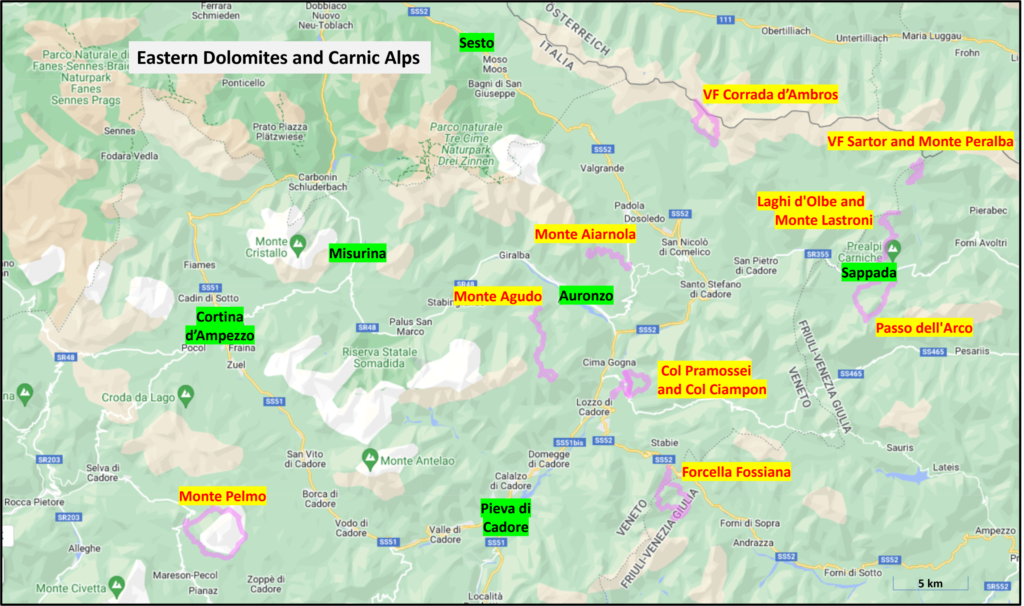
Pre-meet Activities in the Eastern Dolomites and Carnic Alps
As a prelude to the meet, Mick and Conrad couldn’t resist the opportunity to enjoy a couple of weeks in the Dolomites. Given Conrad’s job, we had no choice but to go in August at the peak of the Italian holiday period. This brought visions of rammed car parks, queues on the via ferratas and over-full campsites combined with high temperatures and afternoon thunderstorms.
As Conrad had never visited this Italian mountain paradise before and Mick was a veteran of many trips, we decided to try and mitigate some of these concerns by basing ourselves in a quieter, less-frequented area in the east and selected Auronzo di Cadore on the banks of Lago Santa Caterina. This offered easy access to the Cadorine Dolomites, the Marmarole group to the south, the Sesto group to the north and the Carnic Alps close to the Austro-Italian border from the Piave valley to the east. This location also had the advantage that Mick had done little in this area before and was therefore keen to see what it had to offer.
Even in April, finding rooms in this period was challenging, but we finally managed to book consecutive half-board accommodation in two small family-run hotels: one in Auronzo di Cadore – Albergo Serena (with a view of the Tre Cime from our bedroom window) and the other in the nearby village of Laggio di Cadore – Albergo Giannina. Both can be warmly recommended.
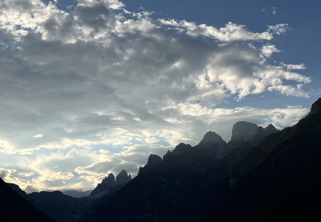
We drove out from the UK and arriving in the Dolomites on a Tuesday, we passed Lago Misurina at the foot of the Tre Cime which had literally hundreds of cars parked up nose-to-tail on the verge and hordes of people. This was a timely reminder why we needed to avoid the honey pots!
Over ten days, we did a variety of via ferratas, mountain ascents and hillwalks across the area and were able to avoid the crowds without losing any of the enjoyment in tackling slightly lower or less dramatic peaks (the proximity of the Tre Cime undoubtably helped here). The views of unfamiliar mountains were equally impressive.
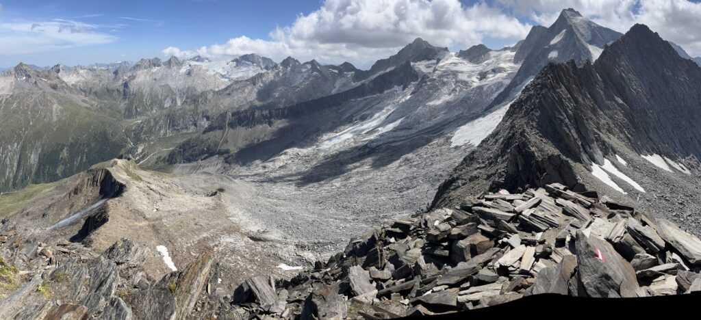
9th Aug – Monte Aiarnola (2465 m) from Passo d’Antonio
This is a mountain in the far eastern part of the Sexten Dolomites group with a straightforward via normale and good views of the Marmarole. The weather was not as good as forecast with lots of variable low cloud but it remained dry and there were just three others on the route who we overtook. The descent of a steep and loose gulley from the summit ridge required great care (Conrad learnt a valuable lesson about loose rocks).


10th Aug – Via Ferrata Corrada d’Ambros from Malga Melin
This interesting and most enjoyable route is in the Carnic Alps along a section of the Austro-Italian border with fantastic views of the saw-toothed ridge of Crode dei Longerin. After a steep climb up through the woods to the open grassy area at Cima Vallona (2532 m) where the route starts, we set off heading west. A narrow switchback ridge awaited us with sections of cabling, a mined gallery, a few stemples and a ladder which were interspersed with some long airy unprotected sections of careful walking. We only met six people on the route. The weather was again rather cloudy but made for some good photos and good views on both sides of the ridge.


11th Aug – Pian del Buoi from Monte Agudo
The old WW1 military road up to Pian dei Buoi was officially closed due to a recent mudslide, so we had to abandon our plan to tackle the Sentiero Attrezzato Amalio da Pra. Instead, we took the chairlift conveniently opposite our hotel up to Monte Agudo (1573 m) and were stunned by the panoramic view of the Tre Cime and Croda de Toni, and across the lake to the Carnic Alps. We then walked along the undulating ridge through beech and pine forest (following a marked snowshoe route!) to the high open meadow of Pian dei Buoi, passing some mined galleries and various other WW1 buildings and remains. We returned partly by our outward route and stopped for a welcome beer at Refugio Agudo.


12th Aug Via Ferrata Sartor and Monte Peralba (2694 m) from near Rifugio Sorgenti
As it was the weekend, we decided to do another via ferrata but in a lesser-known area north of Sappada. We walked up to the Rifugio Calvi and then more steeply to the VF start. This was very enjoyable with steep slabs to be negotiated but was well protected with a new cable and a number of stemples in the right places. This led to a steep path up to the summit of Monte Peralba (2694 m) with exceptional views with some distant summits wreathed in cloud. There were quite a few people about, but it was not mobbed and there was no queuing on the cable once one very slow party had been overtaken.


13th Aug Passo dell’Arco from Sappada
We had planned an easier day using the Sappada chairlift for a moderate walk up to the pretty Lagi d’Olbe followed by an ascent of Monte Lastroni by a WW1 mule track. However, we had to evoke Plan B as the overnight thunderstorm had damaged the lift and it was closed! Our alternative outing was up through the forest on the other side of the valley on a protected path with bits of cabling to Passo dell’Arco, so named after the large natural arch at the col with an unnatural WW1 bunker tunnelled into the cliff underneath. After lunch and admiring the view across to the Carnic Alps, we returned by a different route to complete a circuit back to Sappada.


14th Aug Col Pramossei (1531 m), St Daniele chapel and Col Ciampon from Laggio de Cadore
Having moved hotels in the morning, we decided to spend our afternoon walking from Laggio up to an undulating wooded ridge overlooking the village. This eventually descended to some cables that led down to the historic Saint Daniele Chapel, dating back to 1350, perched high above Col Ciampon which houses a substantial WW1 Italian military village due to its commanding position above the Cadore valley. This has been restored and is now an open-air museum.


15th Aug Giro di Monte Pelmo from Passo Staulanza
The circuit of the Pelmo is a classic route which we did clockwise starting with walk up Val d’Arcia then a steep and interesting ascent of a gulley and ridge that led up some stemples and diagonally up scree slopes to the high point of Forcella Val d’Arcia (2476 m), then down a steeper and much looser slope with an opportunity for some scree running and past some cable protected sections down to the Refugio Venezia. A return was made on a good path through the latschen and wooded slopes below the famous dinosaur footprints which unfortunately we didn’t have time to see. A cracking mountain day!


16th Aug – Col Ciampon and Col Piccolo from Laggio di Cadore
It was again very hot and the forecast was for afternoon thunderstorms so we opted for an easy day and spent some more time doing the full round of the military village and its installations on Col Ciampon and reading all the information boards etc. It was a strategic position to be able to fire on an enemy trying to cross the river at the Tre Ponti bridges below, which were also secretly mined. Then we walked across to the next village Vigo di Cadore and its lovely 14th century chapel and up to the other fort at Col Piccolo. It turned out that the Piccolo site was still owned by the Italian military but all the buildings a had been systematically stripped of anything of value and the site was eerily derelict and overgrown.
17th Aug – Lagi d’Olbe and Monte Lastroni (2449 m) from Sappada
More thunderstorms were again forecast but at least the Sappada chairlift was working. We enjoyed the walk up to the Lago d’Olbe with its fine reflections and then ascended Monte Lastroni by a WW1 mule track. This summit had superb views of Monte Peralba and Monte Chiadenis with Rifugio Calvi beneath. We examined a few WW1 emplacements and walked back to the top chairlift station as the clouds were rapidly thickening and lowering. There were a few distant peals of thunder and the chairlift had been stopped as a result. We queued for about 20 mins then it was restarted and took us down to the middle station, where it stopped again. Then a torrential thunderstorm began which lasted about an hour with lots of lightning and thunder directly overhead while we sheltered with a group of Italians in a wooden hut by the lift station. When it finally stopped, we swiftly walked down as the lift was not going to restart. Thankfully we had resisted the temptation to do a via ferrata.


18th Aug – Forcella Fossiana (1986 m) and Rif Giaf from Passo della Mauria
We were planning to finish with another via ferrata on our last day – Sentiero Attrezzato Olivato, but another forecast of afternoon thunderstorms cautioned us to just do a walk, given the slightly late breakfast timing. We started from the same pass but did an alternative ascent below Monte Miaron. This was a pleasant walk initially up through the mixed beech and pine forest, then up mostly well-consolidated steep scree to Forcella Fossiana to the northeast of Monte Cridola. After a lunch we headed down to Monte Boschet and Rifugio Giaf, then an undulating descent through more beech woods with a couple of screed side valleys to cross before reaching the car. We had a bit of light rain near the rifugio but no thunderstorm this time.


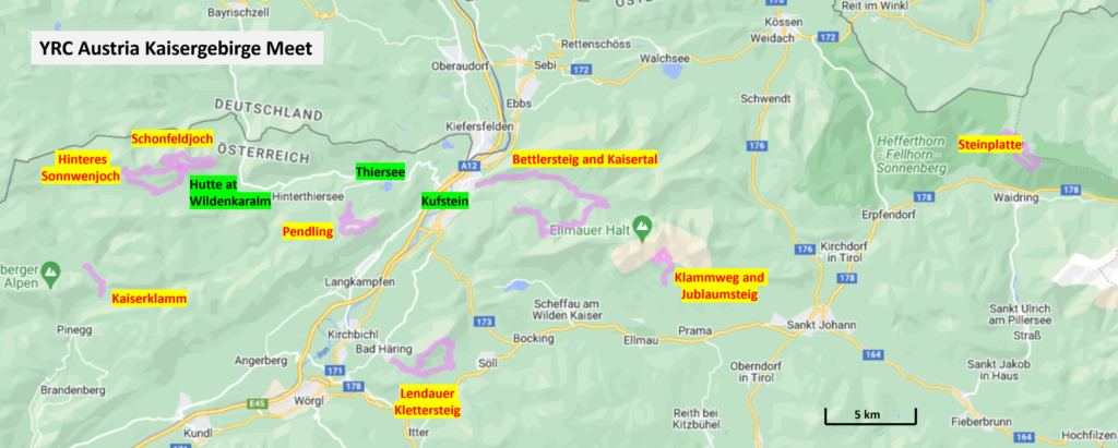
Kaisergebirge and Zillertal Meet
We felt our pre-meet activities in the eastern Dolomites had helped us acclimatise to the unaccustomed heat and certainly boosted our fitness. We passed queues of traffic coming into the Dolomites, crossed the Brenner Pass and headed for the Austrian Tyrol where Dieter told us that poor weather had just been replaced by blue skies and sunshine just in time for the meet.
Participants: Mick Borroff, Conrad Tetley, Ann-Karin and Kjetil Tveranger (and Niko!)
19th Aug – Travel to Wildenkaralm
Mick and Conrad travelled from the Dolomites to meet with Dieter and Ina at their house in Thiersee, near Kufstein, and after tea and cake under a shady tree beside the lake, we were accompanied to their spacious traditional wooden cabin – the Klausen Hütte which was built in 1859 in the picturesque alpine pasture of Wildenkaralm. At about 1400 m, it enjoys a commanding view across to the snow-capped peaks of Grossvendiger and Grossglockner to the east and four more ranges of blue mountains particularly in low angled morning light. Complete with limited electricity from a solar panel for lighting and device charging, running water outside on tap piped from higher up the hill and a flushing toilet, a two-ring gas stove, a wood-burning stove (which we didn’t need to use) and comfortable beds, the cabin was well-equipped and we looked forward to the prospect of breakfast on the terrace in the morning. Ann-Karin and Kjetil were to join us later in the week.


20th Aug – Schönfeldjoch (1716 m), Wildenkarjoch (1747 m) and Angerljoch (1854 m) from Wildenkaralm
The morning views from the terrace were superb but we had to put the umbrellas up to create some shade to eat breakfast as the sun was simply too hot otherwise. Given the heat, we decided just to walk from the alm on a trail which led up to the Schönfeldjoch and then traversed the easy ridge to Wildenkarjoch and down to the Wildenkarsattal col above the alm. We then decided to ‘have a look’ at the route up the Angerljoch and Krenspitze with a view to climbing them as part of a traverse to the Hinteres Sonnwendjoch. We completed the traverse of Angerljoch which was loose, very exposed and unprotected. At the next col before the Krenspitze, the faint path disappeared and we agreed to leave it for another day. We carefully picked a route down a steep scree slope avoiding small crags to the mountain pines below and took a thin path back to the alm.


21st Aug – Lengauer Klettersteig and Grosser Pölven (1595m) from Bad Häring
We agreed that this easy klettersteig (also known as VF Sinwel) and a subsequent traverse of the Pölven would be a good initial route to give us fine views of the Inn Tal and the Kaisergebirge peaks. The walk-in was very hot despite the shade and soon became very steep with a series of zigzags leading up to the start of the cabling. As this was more of a protected path, we had only taken helmets and the aided sectioned with its ladder was over all too quickly. The remainder of the walk followed an undulating wooded ridge via a second cross which was also a great viewpoint and then we descended along farm tracks and pleasant shaded paths past the pretty Annakapelle back to the car.


22nd Aug – Klammlweg and Jubiläumssteig from Wochenbrunneralm
A round of these two Wilder Kaiser protected paths in the Ellmau region was the next objective. Having reached the Gaudeamshütte, Mick and Conrad soon turned off the track and climbed west behind the Gruttenkopf to the start of the Klammlweg. An ascent was made via cables, ladders and stemples to arrive at a delightful col with fine views. This was made more delightful by the Gruttenhütte only being minutes away where cooling refreshments were taken. Following a relaxing ten minutes chilling out looking over the Kitzbüheler mountains, it was time to tackle the much more interesting Jubiläumssteig via ferrata. Whilst still effectively a protected path, this popular route was significantly longer and more exposed than the Klammlweg. The circuit was completed by descending back to the Gaudeamshütte and Wochenbrunneralm.


Later in the day Kjetil, Ann-Karin and their large friendly dog Niko arrived having driven for three days from their home in Norway. We all met up in Thiersee and travelled up to Wildenkaralm.
23rd Aug – Hinteres Sonnwendjoch (1986 m) from Wildenkaralm
As relief after the Norwegians’ long car journey and a breakfast rain shower, we decided to walk up from the alm to the area’s principal summit. A walk from the hütte took us up a gradually steepening path to the summit cross on the Hinteres Sonnwendjoch. We then followed a descending path to Bärenbadalm. Lunch was taken and then we visited Ackernalm, the highest traditional alpine cheese dairy in the Tyrol at 1383m. As well as being a cheese shop, tasty Zipfer beer was sold and we all indulged! From there it was a steady walk down the valley and then back up to the hütte.


24th Aug – Zillertal Alps: Berliner Hütte
The morning broke with great expectations as this was the first of our two-day visit to the Zillertal region and one of the highlights. The plan was to walk up to the Berliner Hütte and the following day, traverse the Schönbichler Horn. Given the heat, we wisely made the second day less arduous by taking two cars and leaving one at the Schlegeisspeicher reservoir and the other at the Breitlahner. We all set off from the Breitlahner car park for the three hour walk up the Zemmgrund valley to the Berliner Hütte. At approximately the half-way point a torrential thunderstorm began, fortunately at the exact same time we were walking past the Grawandhütte and managed to take shelter. The remainder of the walk followed pleasant alpine meadows, accompanied by inquisitive cows, past the traditional Alpenrosenhütte and finally up a flagged mule path to arrive dry at the magnificent baronial-style Berliner Hütte (2042 m) built in 1878.
After settling in and a refreshing beer on the terrace, we were treated to an extremely tasty four course meal including beef and local produce.


25th Aug – Zillertal Alps: traverse of Schönbichler Horn (3134m) from Berliner Hütte
Over a substantial breakfast it was decided that our planned climb would be too difficult and dangerous for Niko, so Ann-Karin opted to take him with her to visit the Schwarzensee alpine lake and then descend to Breitlahner following our outward path.
Mick, Kjetil and Conrad therefore set off on the three and a half hour walk to the summit of the Schönbichler Horn. Initially, descending to reach the foot of the mountain and then picking up the meandering path that led up above old moraines to the summit. In consideration of how warm the day was, a number of rest stops were taken before reaching the col before the splintered summit. The climb to the top involved scrambling up a series of rocky sections with the aid of a cable. Once at the summit cross, a fantastic panorama of the Zillertal Alps was laid out before us.
Descending the mountain was in theory quite straightforward involving following a good path to the Schlegeisspeicher reservoir. Initially, the track was protected, however, this soon ceased and then the engineered path was made up of mobile “coffin lids” – large oblong pieces of slate, with rocks and scree. At roughly two thirds of the way back to the car park, we stopped for a drink at the Furtschaglhaus. We then made our way back to the car, just before another thunderstorm began … the walk seemed to take forever. Kjetil and Conrad were very grateful to Mick for his decision to take two cars, alleviating the walk to the Breitlahner car park which would have added a further 7km and 500m of descent.


26th Aug – Pendling (1563m) from Gasthof Schneeberg
After the previous day’s long walk and with another forecast of possible thunderstorms, it was decided to do something a little gentler and climb the nearby Pendling. After parking the car, a steady ascent was made initially on forest roads and then through meandering alpine forest. The trail became steadily steeper until the top was reached. After taking lunch at the summit cross, a short walk to the nearby Pendlinghaus afforded all the opportunity of well-deserved beer and chocolate cake whilst overlooking the beautiful Wilder Kaiser and Zahmer Kaiser ranges. After a longer than usual break, the descent was made with the help of a friendly and knowledgeable German family whose daughter took a great shine to Niko. We almost managed to get back to car before the rain started, but not quite!


Dieter told us that there was a very poor forecast with snow possibly even as low down as Wildenkaralm on Monday through Wednesday, so he very kindly offered us the use of an empty apartment in Thiersee for the rest of the week.
27th Aug – Rest Day
The weather had definitely changed for the worse. We awoke to hill fog and rain, so we finished tidying the cabin and descended to Thiersee which also had low cloud on the surrounding tops. We made ourselves comfortable in the large apartment with its lovely view across the Thiersee lake, while it steadily rained yet again.


28th Aug – Thiersee
Another wet and misty day was in prospect, so Mick finished helping Kjetil with setting up his new GPSMap 67 device and checking the custom mapping worked okay. Plans for a possible Norway meet in the Jotenheimen in 2025 based at Kjetil’s cabin were also discussed. We all walked round the lake during a dry spell in the late afternoon before dinner.
29th Aug – Kaiserklamm from the Kaiserhaus
After a leisurely and very damp start after the rain had stopped, Dieter had recommended we visit the Kaiserklamm in Alpbachtal. This is a narrow natural river gorge approximately 1km long which was used by loggers to ‘drift’ logs to a collection point until 1966. Whilst only a short walk, the path was spectacular insofar as witnessing the power of the rushing water below and the setting which is humid and varied in terms of flora. On the walk, a number of kayakers were evaluating ‘running’ the Brandenburger Ache river, however, none actually did so during our walk. Probably a wise idea as the water would have presented many dangerous challenges to all but the very best kayakers (check out the YouTube videos)!


In the evening we enjoyed a very pleasant Indian dinner with Ina and Dieter followed by an interesting slideshow of their 2018 Kanchenjunga trek where we first met, and their subsequent visit to a colourful three-day dancing festival by the Buddhist monks at the gompa in Olangchung Gola.
30th Aug – Bettlersteig and Kaiser Tal from the Kaiserlift
This walk took the group (including Niko!) to a starting point at the Kaiserlift, one of the oldest chairlifts in the Tyrol, but thankfully revamped in 2015! At the bottom lift a discussion took place regarding whether Niko could fit into one of the dog boxes attached to a specially adapted chair. It was decided to give it a go. Once the moment arrived, Niko was a little apprehensive to get in, however, after some ‘persuasion’ from Kjetil he did so. From the Brentjoch top station (1256 m) the views were extensive. After a short ascent to the Kaindlhütte, the Bettlersteig route was taken down into the relatively wild Kaisertal to the Anton-Karg-Haus and its chapel. The 18km route followed predominantly a steeping descending path through mixed alpine woodland with several streams to cross. The route included a mixture of features including bridges, log steps, stemples and water crossings. The final stretch of the walk visited the Tischofer Höhle (Kufstein’s equivalent of Victoria Cave above Settle) with its impressive portal, then a climb down and back up a new steel staircase to cross a deep gorge. From there, the walk was a downhill plod back to the chairlift car park with rain just beginning to set in. Niko was very relieved to see the car after his chairlift adventures!


31st Aug – Steinplatte (1869 m) by the Wieslochsteig from Stallenalm
As the meet drew to a close, on the final day a plan was hatched to climb the Schuastergangle klettersteig on the Steinplatte. After approximately an hour’s drive involving inquisitive armed Polizei stopping the only English car crossing the Austro-German border, Mick, Kjetil and Conrad arrived at the damp car park. After considering the previous night’s rain, wet rocks and the mist shrouding the summit, a decision was taken to ascend the Steinplatte via the easier Wieslochsteig instead. The very pleasant route involved ascending several gullies and protected paths most lined with alpine flora. Once at the top a short lunch break at the summit cross was taken and a descent via the normal route to a welcoming hütte where customary refreshments were taken.


In the evening we took Dieter and Ina out for a meal and enjoyed a superb dinner at Alpengasthof Schneeberg renowned for its traditional Austrian cuisine.
1st Sep – Departure
We tidied up the apartment, said our goodbyes and gave final thanks to our hosts Dieter and Ina, without whom the meet would not have happened. Mick and Conrad had a two-day drive back to the ferry at Ijmuiden, and Kjetil and Ann-Karin also had a couple of long days ahead of them to reach their house in southern France.
The four participants really enjoyed this relaxed meet to a mountain area in Austria not visited by the club before, with the outing to the Zillertal being the icing on the cake. Careful selection of routes at the weekends helped avoid the crowds and parking was never a problem. The weather could certainly have been better during the second week and the prospect of forecasted thunderstorms constrained our route choices away from the klettersteigs.
Further Reading
Wilder Kaiser – 65 routes in the Kaisergebirge. Sepp and Marc Brandl. Rother Bergverlag, 2022.
We found this to be an excellent guidebook to the area complete with GPX tracks and did a number of their ‘top ten’ routes. Note this guidebook is in German, but Mick painstakingly translated it into English using Google Translate. [NB Rother subsequently released their new app which has English translations as standard. These are also available on the Outdooractive navigation app.]
Information on the local via ferrata/klettersteigs can be found at: https://www.via-ferrata.de/wilder-kaiser/
Super report, sounded like great and varied trip
Congratulations on your wonderful trip!… Well done avoiding the worst of the thunderstorms and completing such a lot of routes. Must have been great to meet up with Dieter and Ina again and stay in their hut. Super pics. Sad to see glaciers shrinking away….