La Cueva de San Antonio
John Middleton.
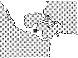
We rubbed the sign and saw it said “Prince El Paraiso”, we let out a great sigh of relief, we had finally made it, Two hours had passed since we left our cosy little hotel at the end of the road village of El Estor on the shores of Lake Isabel. Two hours of almost continuous four wheel drive, across a 50m wide and half metre deep river, over precariously balanced planks crossing lesser steams, through dense forest, around maize fields, and all the time in door deep red mud. It may have been just 15km but it was certainly quite an adventure in its own right.
We knocked at the door and asked in our halting Central American Spanish for a guide to take us to the entrance of the French cave (discovered in 1992 and unvisited since). The Finca is a maize and coffee farm also situated on the edge of the lake and has several huts where visitors can stay – presumably they arrive by boat though! Rodriguez, the rotund and laughing farm manager obliged us and we promptly jumped into the nearby Rio Caquija San Antonio, a surprisingly warm river which shortly led into the forest. Around the first bend the reason for the unusual warmth became apparent when a streaming water fall entered our river from between the junction of the limestone and volcanic base rock. Once past this we entered a fantastically eroded gorge. Hand sized spiders ran along the boulders at stream level. Rodriguez assured us they were harmless but we were not convinced! Cascade followed cascade until eventually a still, bottomless black lake emerged from between the giant portals of a cave.
We swam in, the entrance was perhaps 6m wide and 15m high, inside, the ceiling vanished from sight but we had to continue swimming for over 400m to a short cascade, more swimming, and a 6m high waterfall. Once this was excitingly negotiated the passage mushroomed into one of the largest and most beautiful imaginable. Yellow flowstone cascaded down all the walls and often also covered the floor. The roof was measured to 50m and the passage width on occasion exceeded 40m. Progress was rapid and in no time we had covered over a kilometre terminating in a 20m high waterfall. Awe inspiring! If we had brought ropes with us we could have entered via the top entrance, covered almost 4km of passageway, and descended 206m. What we did do was not difficult but it certainly was spectacular, beautiful, highly sporting AND we still had to get back to El Estor before dark.
For anyone who happens to be in this part of Guatemala then El Estor makes an excellent base. It has no tourist infrastructure as such but, for us, after eight days of eating nothing but beans, rice, and tortillas in various forms, its fresh fish and meat are very welcome.
There is also a surprising amount to do here. Apart from known caves, local farmers informed us of considerable potential in the mountains; there is excellent walking; boats can be hired to visit the Rio Polichic delta swamp where I certainly had my best views of birds, monkeys, and plant diversity anywhere; hired boats can also get you to the Castille San Fillipe, some 25km across the lake – this was originally built to keep the English pirates out, from there it is not far to the Rio Dulce gorge, the Caribbean, and the garifuna town of Livingston. Big game fish (Tarpen) abound in the lake and there is always the primary and secondary forest with all its excitements (danger!).
The limestone country to the north, Coban, is also quite incredible with the largest and most impressive cockpit karst I have ever seen, major river caves, cave potential galore, and the amazing 600m long natural tufa bridge at Semuc Champey built over the foaming Rio Cahabon.
We had six punctures exploring this wild region from Lanquin and after bulk discounting managed to get our puncture repairs down from around £5 to £1.
