The Caves Of Yamaguchi
By Mr. Edw. Gauntlett, F.R.G.S.
[We have been favoured by Dr. E. A. Baker with the following extracts from a letter received by him from Mr. Gauntlett of Yamaguchi, Japan. Ed. Y.R.C.J.]
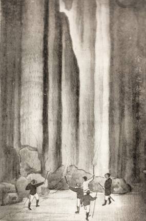
I enclose a set of picture postcards drawn by a famous artist and lately published by an innkeeper at a small country place near here, showing views of a large cavern. This cavern, called the Takiana or Waterfall Cave, has been well known from time immemorial, but the village people took no special notice of it, until I went there a year and a half ago, and urged them to advertise it, and also to blast away a small rock near the entrance, which made it exceedingly difficult, and even dangerous, to enter. I offered to subscribe for a few improvements, including the blasting, and the placing of a boat inside, as the water is over three feet deep in the driest season. This offer woke the people up, and the innkeeper subscribed about £20 for the purpose, so that now the cave is easily accessible to anyone.
Unfortunately many of the fine stalagmites in one part of the cave have been taken away by former visitors, but in other places the cave is in good condition, and the stalactites are very fine, one fine pillar is from 40 to 50 feet in circumference and 60 to 70 feet high, absolutely straight. The water tunnel of this cave, if it ran in a straight line, would be about six miles long. At a place six miles to the N.E. there are five small caves, two of which are just large enough for one to enter on hands and knees, and the others very small; and into these a stream runs, which is never quite dry. After a heavy rain these live entrances are absolutely hidden, as I saw for myself the other day after a storm. Some men in the village threw a quantity of young rice stalks into the water just where it entered the holes, and they were finally found in the Takiana Cave six miles off, which proves the connection.
I have made a rough plan, but I have not had time to make a correct survey, and have asked the Provincial Government to do so, after which I propose writing a book on the subject. The cave has many huge chambers.
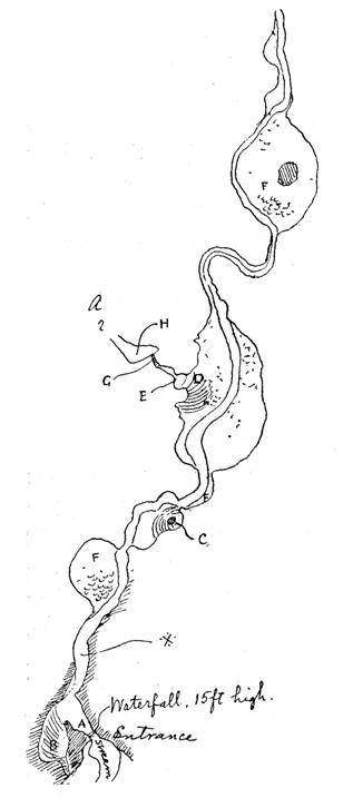
Referring to the Sketch Plan, the water just inside the entrance, at the top of the waterfall, is about 50 feet deep for a distance of 40 feet. Then, on the left, is a large chamber B rising at an angle of about 30° and culminating in a very small entrance on the face of the cliff. From this place forward we have to go by the boat till we come to the place marked F, which means “font.” The floor here is a mass of these stalagmitic basins, rising very slightly at first and then very steeply, until they form the most perfect imitations of casks full of water; and they are all in fact full. Then proceeding, and crossing over to C, we climb up a pretty steep place and crawl into a room behind a pillar, called by the villagers ” The Flower Garden,” but here the place has been spoilt by visitors taking away the stalagmites. A short distance beyond this the chamber is exceedingly large, and I never saw the top, even with a number of torches, until I took magnesium. The point D is called “The Temple Altar” and is a raised platform from which the view is magnificent, the torrent roaring below you and the roof high above your head.
At E is “The Pillar of Gold,” the huge pillar already referred to, after which we climb up a rock, G, the perfect imitation of a petrified waterfall, called “The rock on which even a monkey would slip,” and then through a narrow passage to the edge of “Hell’s Mouth,” H, – a fearful pit. This I have never had the courage to enter, and only one man has ever been known to do so, and he was sent by a newspaper editor, who had seen my letters in the papers. The rope he tied around him was 160 feet long, and was even then about 40 feet too short to reach the first ledge. However, he succeeded in getting down, and went on alone for three hours, seeing many interesting places.
The main stream up to K is as far as I or anyone have gone, because one must either swim or have a boat, as there is absolutely no foothold.
Referring to the Sketch Map of the district enclosed[1], I must first say that Yamaguchi is situated at the end of the Main Island to the south-west, and is the capital of the province of the same name. The Takiana Cave, described above, is undoubtedly the finest in Japan, and is marked No.1. No. 2 is a small cave with two entrances side by side externally, but with one above the other inside. This is a most interesting cave, and promises some reward for exploration, for I believe it is connected with a deep pot-hole above. My next trip will be to descend this pot-hole. No.3, it would seem, was discovered by myself, for no one seemed to know about it. The entrance is fairly large but rather risky, for you have to jump about 8 feet on to a narrow ledge, with a drop of about 6 feet on the right and 60 on the left, and this deep drop is exactly under the only point where one can enter. Inside it is full of coral-like incrustations of great beauty and continually ascends and descends. The mouth of the cave is high on the steep side of the hills, and hidden by bamboo.
No. 4 is a cave with a very small entrance, but inside has several chambers one above the other. I have not as yet examined it well.
No. 5 is the entrance to a very famous cave, but the real entrance is at No. 6. The streams run into three holes, the two westerly of which are very large; and after a spell of fine weather it is possible to go right through the mountain from one side to the other. As the crow flies the distance is about a mile and a half, but owing to its windings the passage is about two miles long. The exit No. 6 is very large, and on one side there is a branch cave, a small one, in which some soldiers hid from an enemy in ancient times. The ceiling of this cave is a mass of stalactites, and very often there is not a drop of water in the first half mile from No. 6. The other day, however, when I went there after a storm, it was quite a large river, which, after proceeding about two miles, drops into a pit with a great noise. It is my intention to enter this pit in the dry season, for I have seen it several times quite dry. A quarter of a mile beyond this, deep down in the valley, I found a pit from which a fierce current of air was blowing, which was evidently displaced by the water. No.7, to the west, I have only just discovered, but have been totally unable to enter, for want of a boat or raft, the water being about six feet deep. The village people say that there is no end to it. The entrance is low and wide, but inside it is said to lead to large chambers.
There is a very large and deep valley, or swallow hole, at the bottom of which a stream appears, and after running about twenty or thirty yards, again disappears into the mountain. This I have marked as a continuation of the stream from No.9, but this is only a conjecture.


